Kunchikal Falls
Address
SH 52, Nidagodu, Karnataka 577448
Open Hours
6:00 AM–6:00 PM (Subject to security restrictions)
Weather
Cool and misty with heavy rainfall during the monsoon season
Crowd Level
Low
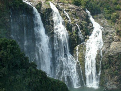
Kunchikal Falls is widely recognized as one of India's highest waterfalls, majestically cascading from a height of approximately 455 metres (1,493 feet). Located deep within the lush landscapes of the Shimoga district near the Masthikatte-Hulikal region, it serves as a testament to the raw, untamed beauty of the Western Ghats. The waterfall is formed by the perennial Varahi River, which creates a dramatic, tiered descent over a rugged expanse of hundreds of boulders, providing a spectacular visual display that draws nature enthusiasts and photographers alike.
Historically, the area surrounding Kunchikal Falls was a quiet, pristine wilderness, largely untouched by mass tourism. The geography of the falls is defined by the steep inclines of the Shimoga district, where the water gains significant momentum as it navigates the rocky terrain. While the falls are a geological marvel, the site has been significantly transformed by modern industrial developments, specifically the construction of the Mani Dam. This hydroelectric project was established to harness the river's energy, effectively regulating the water flow that once defined the waterfall’s year-round intensity.
Today, the waterfall's character is heavily dictated by the monsoon cycle. During the peak rainy season, the Varahi River surges, restoring the waterfall to its former glory as a powerful, multi-tiered cascade. During this time, the lush greenery of the Western Ghats acts as a vibrant backdrop, creating a tranquil environment that feels worlds away from the urban noise. The absence of heavy commercialization has ensured that the site remains remarkably clean and free from the environmental degradation often found at more accessible tourist destinations.
Due to the presence of critical infrastructure like the Mani Dam and underground power stations, public access to the immediate base of the falls is strictly regulated by security personnel. This limitation on movement has preserved the site's ecological integrity but also means that visitors must respect local security protocols. It remains a destination for those seeking solitude, nature photography, and a deep appreciation for hydroelectric geography. It is advised to plan a trip during the monsoon or immediate post-monsoon months to experience the waterfall at its most vibrant state.
Visitor Information
Famous For
Being one of the highest waterfalls in India, stunning rock formations, and the scenic Varahi River basin.
Visit Duration
1–2 hours
Best Time
July to October (Monsoon season) for peak water flow.
Route Options
Accessible via NH 169 or SH 52 from Shimoga; local taxis are recommended as public bus connectivity to the immediate dam area is limited.
Parking
Limited parking available near the designated viewpoints.
Entry Fee
No official entry fee, but access is restricted to public view points.
Camera Fee
No specific fee, but commercial photography may require permits from district authorities.
Restaurants Nearby
Small tea stalls and local eateries available at Mastikatte junction.
Toilets
Very limited; visitors are advised to use facilities in nearby towns like Hosanagara.
Drinking Water
Not available on-site; carry sufficient water supplies.
Wheelchair Access
Not accessible; the terrain is rugged and steep.
Medical Facilities
Primary Health Centers available in Hosanagara and Mastikatte.
Weather Alerts
Slippery rocks and heavy fog are common during the monsoon; avoid climbing wet cliffs.
Pilgrim Information
Darshan Timings
Not applicable as this is a natural site, not a place of worship.
Special Poojas
None
Prasadam
None
Free Meals (Bhojan)
None
Temple History
The site holds no specific religious mythology but is revered by locals as a manifestation of the holy Varahi river.
Nearby Sacred Places
Humcha Jain Temple and the various ancient shrines in the town of Teerthahalli.